Coeur d'Alene
National Forest
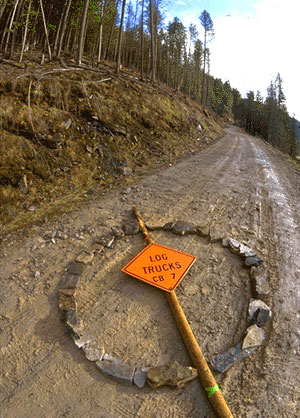
Zero Log Trucks Circle. At the beginning of a logging road leading high up into the Coeur d'Alene Watershed an activist found this sign on the ground and using it as a slash across the circle of rocks, made the obvious point. The Coeur d'Alene may be the most heavily roaded forest watershed of all National Forests in the country. Road densities in this region reach an average of 10.85 linear road miles per square mile, and in some places as high 20 linear miles per square mile.
Most people think that land set aside as a National Forest is truly protected, but that is not the case. There are more thna 440,000 miles of roads cut through our National Forests--more than 8 times the number of miles in the entire Interstate Highway System. These roads are built in large part to help private timber companies log the public's trees, and taxpayers subsidized their contruction to the tune of almost $100 million in 1997 alone! The Forest Service claims that visitors want the roads, but it's doubtful that they come to see the clearcuts that they lead to. Logging roads and clearcuts not only increase water yields to streams, they also cause the land to slide away, destroying stream channels and fish habitat with heavy sediments and bedload. As stream channels fill up with sediment, they become wider and more shallow, increasing their flood plain area. This phenomenon, combined with increased water yield from snow melts on de-forested hillsides, cause extreme flood events. What used to be one hundred year flood events are now occurring at a rate of once or twice a year in this region.
For more information contact:
The Lands
Council
Wildlands
Center for Preventing Roads (Road Rip)
Sustainability
Homepage