VIRGINIA
Jefferson National Forest
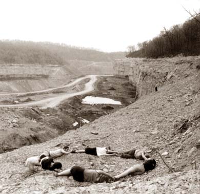
 Miners Zero. The stave from an old oak
barrel makes a zero upon a pile of slag in a huge coal mine in Jefferson
National Forest. It's alarming to discover that much of our eastern national
forests-- areas which are colored green and called "National Forests" on
the maps we use--aren't forests at all, but coal mines, small towns, farm
fields, etc. The truth is that less than 50% of the land designated as
"National Forests" is actually public land. Much of the land that falls
within designated national forest areas are simply "purchase units"--
parcels of land the Forest Service would like to add to public ownership
one day. A nice vision, yes. But the majority of Americans who look
at the maps and see a green area marked "National Forest" are fooled into
thinking this is publicly-owned forested land.
Miners Zero. The stave from an old oak
barrel makes a zero upon a pile of slag in a huge coal mine in Jefferson
National Forest. It's alarming to discover that much of our eastern national
forests-- areas which are colored green and called "National Forests" on
the maps we use--aren't forests at all, but coal mines, small towns, farm
fields, etc. The truth is that less than 50% of the land designated as
"National Forests" is actually public land. Much of the land that falls
within designated national forest areas are simply "purchase units"--
parcels of land the Forest Service would like to add to public ownership
one day. A nice vision, yes. But the majority of Americans who look
at the maps and see a green area marked "National Forest" are fooled into
thinking this is publicly-owned forested land.
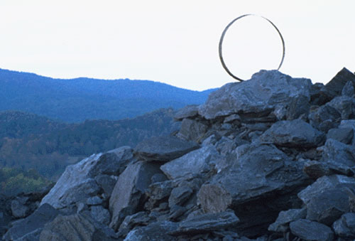
Stripmine Zero. A monsterous coal mine
sits in the middle of designated Jefferson National Forest land
along the Virgina-Kentucky border.
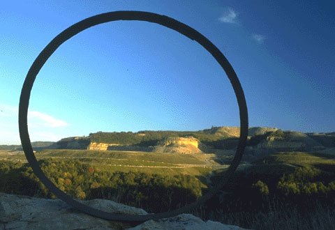
TopGone Circle. This striking circle
shows what is happening to many of the mountain tops in Virgina and other
coal rich states. Like you see here.....the tops are simply removed to
get the coal. Some of this area was saved because of an old family cemetary
and becasue a core group of people cared. The story of
this circle is fascinating!
To help achieve Zero Cut in Virgina's National Forests contact:
Virgina
Heartwood
GALLERY
HOME